How To Properly Read Nautical Charts
Nautical charts show all the features necessary for your safe navigation from here to there. To get that information, however, you must know how to read a chart.
Several outstanding boating safety organizations teach people how to use nautical charts, and every boater should use those opportunities. Before you take a class – or even if you’re a seasoned sailor plotting your next cruise – it helps to familiarize yourself with common chart elements. Depths and dangers: The small numbers on a nautical chart are water depths at “Mean Lower Low Water,” which is the average depth at the lower of each day’s two low tides. Measurements at this level help boaters determine the closest underwater clearance possible for their boat. Depths (also called soundings) are shown in either feet, fathoms (6 feet), or meters (3.28 feet). To see which unit of measure the chart is using, check the large magenta letters at the top right corner of the chart. Subscripts, such as 52, show depths in fathoms and feet (5 fathoms and 2 feet) or decimal meters (5.2 meters). Dangers like rocks, reefs, wrecks and other obstructions are depicted with a variety of symbols, depending on the type of danger, it's depth, and other characteristics. Dangers in less than 66 feet of water are surrounded by a ring of black “danger dots,” and have a blue interior.
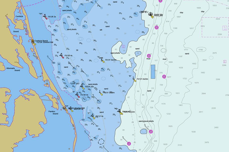
Aids to navigation: U.S. waters have more than 40,000 buoys, beacons, and lights that mark dangers, and show safe water and limits of dredged channels. NOAA nautical charts depict them all, using different symbols that indicate the purpose of each.
Scale: Nautical charts come in different “scales,” the ratio of a given distance on the chart to the actual distance. When you are sailing in open waters, you’ll probably use a small-scale chart (1:100,000 or higher) that covers a large area. When you are close to shore, and more at risk from shoals and other dangers, your large-scale chart (1:20,000 to 1:80,000) will provide more detail over a smaller area.
Distance: Charts of the Great Lakes, other inland lakes, and the Intracoastal Waterway show distances in statute miles, the unit of measure you use on land. Most other charts use the “nautical mile” (1.15 statute miles), the length of one minute of latitude. Traveling one nautical mile in one hour is a speed of 1 knot.
Chart notes: To avoid cluttering the parts of the chart showing navigable water, cartographers show details about certain features, dangers, restrictions, and warnings in “chart notes” elsewhere on the chart. Some notes are about the entire chart; others relate to a specific feature or portion of the chart that uses a nearby label, such as “(see Note B).” Around the outside of the chart, in the lower left corner, is the chart’s edition number and publication date. In the lower right corner is the title and scale of the chart. The full chart title, chart notes and other information are stacked underneath the NOAA logo.
Posted by U.S. National Oceanic & Atmospheric Administration 2014